Flying Tiger Freighter Impacts Coastal Hills Shortly After Takeoff
By Nicholas A. Veronico
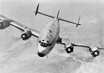
Photo courtesy Lockheed
Copyright & Copy; 2007 Pacific Aero Press
Rain, low clouds, fog and mist covered the San Francisco Bay Area in the late evening and early morning hours of Dec. 23-24, 1964. The day would dawn as Christmas Eve, but for three families this day would become a sad anniversary. The official weather called for scattered clouds at 700 feet under an 1,800-foot overcast ceiling. Visibility was six miles in light rain.
Flying Tiger Line Inc. Flight 282 was scheduled to depart Dec. 23, at 9 p.m., on a domestic cargo trip from San Francisco to New York (JFK). The trip would be flown with Lockheed 1049H N6915C, msn 4812. The scheduled departure time came and went as the company did not have a flight engineer available. A request was made to the Los Angeles, California, station and Flight Engineer Paul M. Entz, age 37, deadheaded on the next flight into San Francisco, arriving at 11:15 p.m. He was an experienced crew member having 4,113 hours of flight time, nearly 93 percent in the 1049H. Entz, having given up Christmas with his family, joined Captain Jabez A. Richard, 49, and Co-pilot Daniel W. Hennessy, 33, in preparing for the flight. Richard joined Tigers on Dec. 4, 1950, and had accumulated 14,911 hours, of which 3,942 were in Lockheed's Super Constellation. Hennessy went to work for the carrier on April 24, 1955, and had accumulated 3,636 hours with 1,277 in type. He was a Korean War veteran and his wife Lorie was a former Flying Tiger stewardess.
The crew had filed an Instrument Flight Rules (IFR) flight plan from San Francisco to Sacramento, then to JFK following Victor Airways, all at 11,000 feet. Flight time was expected to be 9 hours 16 minutes, but the plane carried enough fuel (5,000 gallons or 29,000 pounds) for 11 hours 3 minutes aloft. Its alternate was Newark, New Jersey. Cargo for the flight weighed 41,078 pounds - bringing the total weight to 142,073 pounds - only 27 less than its maximum allowable gross takeoff weight.
San Francisco Ground Control granted N6915C permission to taxi towards Runway 28L at 12:13 a.m. Winds were 15 knots with gusts to 23 from 210 degrees, creating a strong crosswind on takeoff. The Clearance Delivery Controller granted the flight its IFR flight plan indicating that the departure would be along the 287-degree radial also known as the "Golden Gate One" departure. From Runway 28, the Golden Gate One departure takes an airplane through a "gap" between the San Bruno Mountains on the bay side of the peninsula and the coastal foothills to the west. Flight 282, callsign "Tiger Niner Fifiteen," read back the clearance including the climb-out on the 287-degree radial, at 12:21 a.m.
Tiger Niner Fifteen advised the tower that they were ready for takeoff six minutes and 45 seconds later. At 12:28, Flight 282 reported to the tower that they were "rolling." The tower controller noted that the aircraft passed in front of the tower and became airborne at 12:30 a.m.
Witnesses on the ground later said that Tiger Niner Fifteen veered to the right and then made a steeper turn to the left before leveling its wings and continuing to climb. They said the plane entered the clouds wings level. These turns were probably course corrections to return to the correct heading after encountering strong crosswinds.
The tower controller instructed the flight to contact Departure Control at 12:30:22 a.m. Thirty seconds later, Flight 282 made contact and said, "Departure, Tiger Nine One Five, you got us- ah, over?" Departure Control acknowledged the transmission five one-hundredths of a second later and advised the flight to report its progress to 11,000 feet in 1,000-foot increments. The crew responded at 12:31:05, "Roger, how do you have us tracking toward the, ah, gap?" The controller switched radar modes, from 30- to 10-mile scan setting, and asked the crew to report its altitude. They replied, "Nine Hundred" at 12:30:16. Departure Control quickly responded by saying, "...you're left of course of the San Francisco two-eight-seven (radial)."
Flight 282 did not respond, nor did it answer any subsequent calls. The Departure Controller said, "...within seconds after the second transmission, the target stopped, bloomed, and disappeared from the radar scope."
The flight lasted a mere 3 minutes and 30 seconds; it was estimated that the plane crashed at 12:31:30 a.m., Dec. 24, 1964. The Constellation had indeed veered left of its intended course and struck Sweeney's Ridge 4.3 miles from the San Francisco International Airport bearing 257 degrees (roughly 2.5 miles left of its intended course). The left wing struck the east side of Sweeney's Ridge at 840 feet above sea level, cartwheeling the fuselage into the hill at 860 feet, narrowly missing a U.S. Coast Guard radio station. The plane exploded and momentum carried parts up and over the 925-foot summit. The CAB report stated that all four engines were producing power and that none of the control surfaces had separated in flight. Both the ADF and VOR receivers were set correctly.
The Constellation was carrying 41,000 pounds of "general merchandise" and electronics equipment plus 136 pounds of Christmas mail. It was reported that hundreds of "brightly colored women's scarves were found scattered about the area."
Determining The CauseLocal Sheriff Earl B. Whitmore was quoted in Dec. 24, 1964's San Mateo Times, "Had it been 20 feet higher, it might have cleared the ridge." A little bit of an exaggeration but, as always, had it been 100 feet higher it would indeed have cleared the ridge.
A number of factors contributed to this crash. First, the heavily loaded Constellation faced winds and crosswinds from 30 to 35 knots with gusts to 45 knots. As the plane few closer to Sweeney's Ridge, it would encounter turbulence and possibly severe downdrafts.
Second, false VOR indications may have been presented to the crew by a faulty radio transfer switch assembly (or more precisely, the deviation indicator transfer switch) that displays readings from co-pilot's VOR onto the pilot's. The CAB flew a similar "ghost ship" over the crash route in an effort to determine a possible cause, but it was a report from another Flying Tiger Connie that experienced a VOR deviation. That led investigators to look at the crash as a possible contributing factor.
In addition, the co-pilot's request for tracking information may have been an indication of a navigational aid problem or failure. In an effort to ensure this type of accident did not happen again, Flying Tiger Line inspected all radio transfer switch assemblies in its Connie fleet. Three aircraft were found to have faulty switches. Subsequently, the FAA issued an Airworthiness Directive (AD) requiring that each switch be pulled and inspected before it had accumulated 300 hours in service.
Third, the aircraft executed a 55 degree left turn after takeoff. This will never be explained - considering the departure Tiger Niner Fifteen was approved for calls for a slight veering to the right. The CAB report stated, "Since no reason is apparent why the left turn would not have been displayed on the instrument panel, the Board concludes that the crew apparently failed to refer to the total instrument portrayal in the cockpit."
The probable cause for the crash was cited as, "...the pilot, for undetermined reasons, deviated from departure course into an area of rising terrain where downdraft activity and turbulence affected the climb capability of the aircraft sufficiently to prevent terrain clearance."
The Crash Site TodaySweeny's Ridge is sometimes known as the "Plymouth Rock of the West Coast." From here, explorers of the Spanish Portola expedition had their first views of San Francisco Bay in November 1769. The area of the crash was a U.S. Coast Guard reserve off limits to the public. When the Coast Guard decommissioned the site it was dedicated as a part of the Golden Gate National Recreation Area on May 8, 1984. This location offers tremendous unobstructed views of both the ocean and San Francisco Bay, and is home to mule deer, coyotes, bobcats and mountain lions.
Problems quickly arose when attempting to locate this crash site. The official coordinates were off - way off. The CAB's position put the wreck below 600 feet in elevation and the plane could not have crashed there. A study of aerial photographs was made available by Tom Northop and Pacific Aerial Surveys of Oakland, California. Northrop was able to locate aerial photos taken two years after the crash that still showed the burnt foliage around the wreck site. This started the expedition off in the right direction.
After viewing the photos, we decided to put the new "TOPO!" CD-ROM of USGS maps to the test. The product bills itself as "The Ulitmate Tool For Planning Outdoor Activities Around The Bay Area." After reading the manual and quickly installing the software, the crash coordinates from the CAB report were entered. Using the software, coupled with the aerial photographs, we were able to plot the crash site and determine the correct topo, San Francisco South 7.5 Minute Quadrangle Map. Viewing the topo on the screen, the Coast Guard reservation and its buildings were clearly marked. The map was printed on a laser printer and the group headed for the site.
We proceeded to Skyline Junior College, parked in the southern-most parking lot near the trail head and the school's maintenance yard. Although Sweeney's Ridge is not marked on the topo, it is part of the Golden Gate National Recreation Area and is listed in their publications. The group started up the well marked and maintained trail. At the top of the trail, approximately one-half mile, the trail forks. Heading to the right to the top of Sweeney's Ridge, we walked another one-tenth of a mile before turning off the trail to the east. From this point, the San Francisco Jail could be seen below the hillside. All of the Coast Guard buildings were torn down in the 1950s.
The first pieces of wreckage were found 50 yards down the face in an area of thick ground cover. Be aware that parts of the old Coast Guard reservation and radio station have been mixed in with the Connie's remains. This material is primarily electrical components, street lights, and wood. Many people have ventured into this area not knowing its significance. Dozens of beer cans and bottles litter the area.
Once clear of the recent debris, a number of large pieces can be quickly located. One or two flaps, a door complete with latch- handle- and locking-mechanism, and the radio blade antenna were found. A portable am/fm radio that was brutally twisted bore the scars of the crash including a small pebble imbedded in its face. One of the wing fuel cell caps, still wearing a top coat of red paint, turned up. Dozens of pieces with Lockheed part numbers were found, making the wreck even more interesting. Portions of Flight 282's cargo still can be found with a little digging. Blue beads from the costume jewelry plus gloves and scarves still wrapped in plastic - some with melted or scorched packaging - were found in large numbers.
Flying Tiger N6915C is one of the most accessible crash sites with a walking trail less than 25 yards from the point of impact. Its proximity to the coast, coupled with the site's thick vegetation, calls for layers of long-sleeve shirts and good eye protection. No poison oak was noticed during our visit. Sweeney's Ridge is a popular hiking area, yet hundreds of pieces still litter the site more than 30 years later.
This wreck was also the acid test of "TOPO!" Did it work? Outstanding is the answer. After returning to the office, the precise location was entered into the data base and the correct coordinates were provided: Latitude: 37°37'28" by Longitude 122°27'45".